VasMap Vehicle Operation Support System
Product Summary
- i-Con
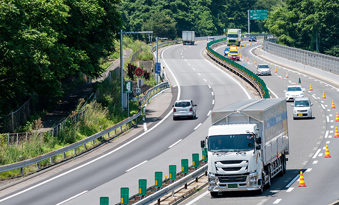
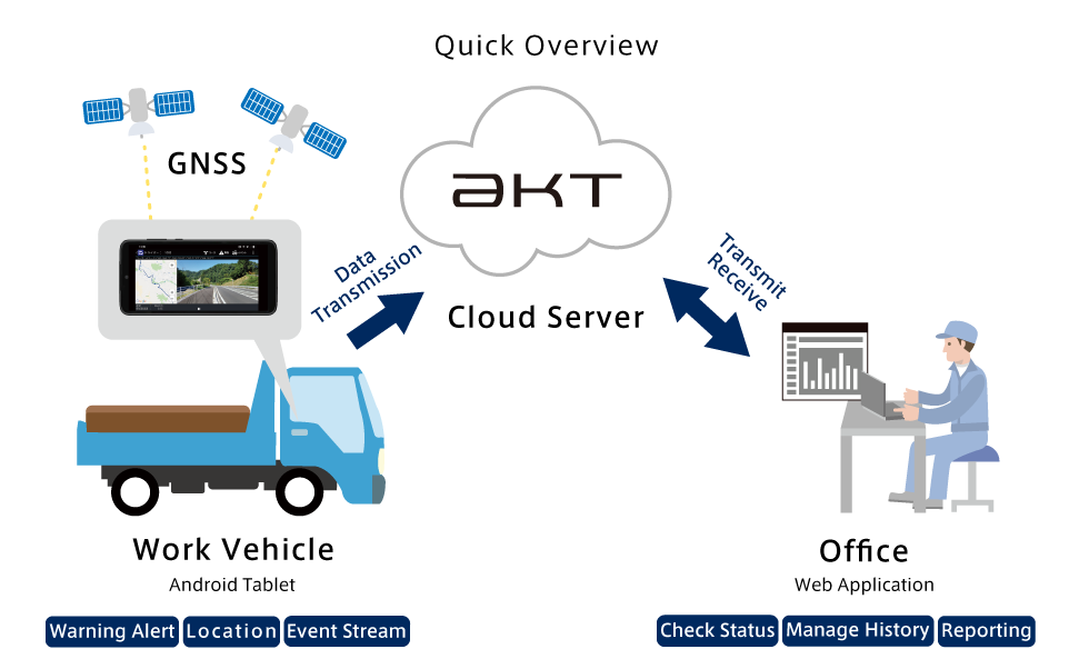
VasMap is a vehicle operation support system that utilises a tablet terminal. VasMap provides real-time vehicle status tracking via the tablet terminal placed inside the vehicle. The tracked data include general info, position, events and more with the ability to send voice alerts to the driver remotely.
Features
VasMap Main Features
- Manage and Track Vehicle Route, Progress, Cargo and More
- Alert Drivers of Potential Risks, Hazards or Dangers
- Optionally Manage Cargo Status such as Temperature
VasMap management utilises an easy to use web based application requiring only an ID and Password to access.
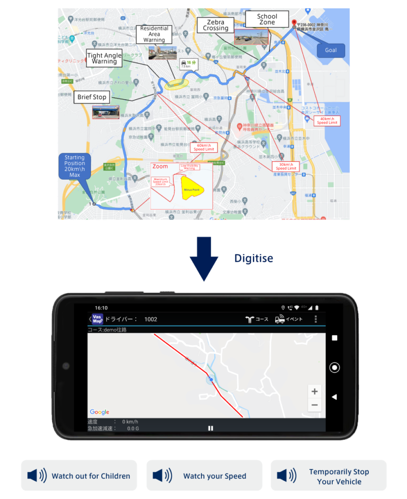
Audio Guidance and Alerts
Audio alerts can be set for both the driver and management. Set a certain area where in the event that a vehicle enters the area, a sound alert can be set for the management side.
In addition to the standard guidance and zone warning, it is also possible to set custom restricted roads, temporary stops, gathering locations and more, along with customisable time warning during work/school hours.
Manual alert locations can also be placed.
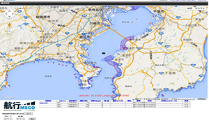
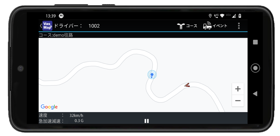
Real Time Tracking
Managed vehicles are shown on the screen using easy to see iconography.
The Icons can show a vehicle’s load status, predicted arrival time, direction, delays and more at a glance.
The manager can also change the colour and icon of the tracked vehicles to reflect the vehicle and also their respective groupings such as company and work area.
The icons can be changed into a flatbed, mixer, dump truck and more.
Event Tracking
Vehicle status such as departure, arrival, speed and more are handled by VasMap as events.
These events are recorded and sent via the terminal in the vehicle.
Event information is automatically sent to the server without the need of human intervention.
The recorded events are time stamped with the option to add additional data such as position.
Manual events can also be entered for events such as load/unload and breaks.
Load/Onload area and time can also be checked along with break time compliance.
Event triggers can also be customised.
※In the event that a manual even trigger need to be sent, please make sure the vehicle is completely stationary before triggering.
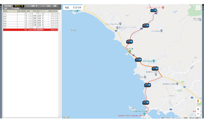
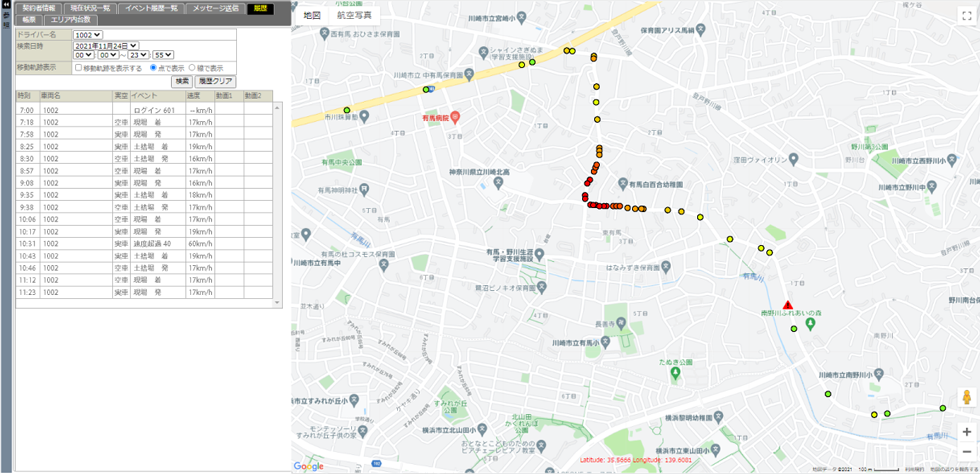
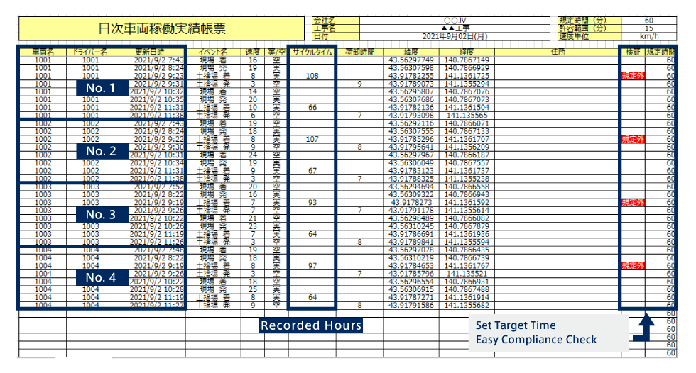
Check Operation History
With VasMap, it is possible to view the record of each individual vehicle in a specified time frame.
Through the View All screen, the departure and arrival time, as well as speeding events can be viewed.
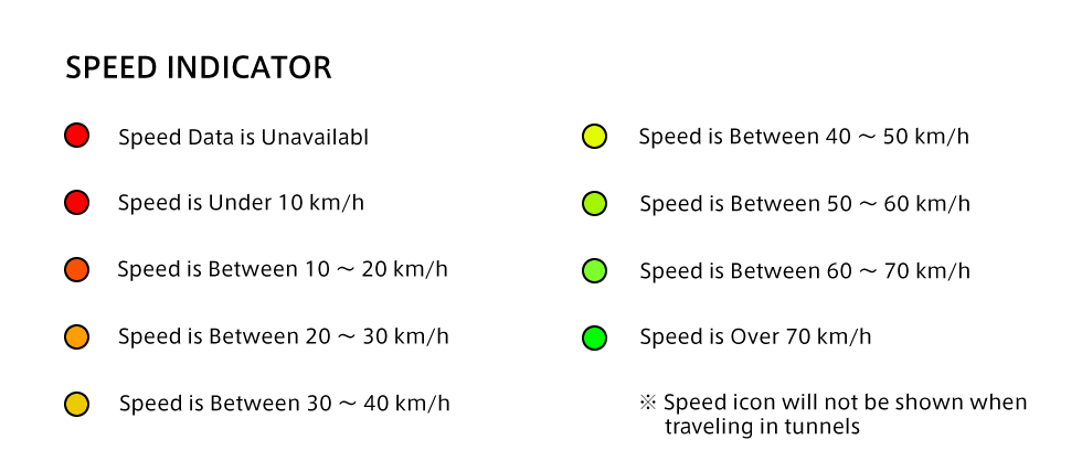
Through the Map History Screen, the trajectory path can be viewed, with speed data and position gathered every 30 seconds where it will be coloured according to its speed to easily determine traffic prone areas and more.
Speeding events are also shown in this window.
VasMap makes coarse adjustment and schedule change decisions easy by presenting all the necessary data in a digestible form.
The data can be used to supplement special requests by local residents in terms of operating hours, routes and more.
On-top of that, the record can be use to gauge driver’s performance, behaviour and compliance for both commendations and recommendations.
※In the even that positional data cannot be determined, no icons will be shown. I.e. in Tunnel
Speed Monitoring
The driver will be alerted in the event of a speeding event.
The speeding settings can be manually set, where if a speeding event is triggered, a “Speeding, Slow Down” Audio warning will be automatically sound.
The event history can also include the event time, location and also speed data.
VasMap also offers customisable speeding event triggers for private worksite roads, access roads and service roads on top of the existing public motorway, highway and roads.
※If speeding continues for more than 10 seconds, dangerous driving warning will be automatically triggered regardless of previous settings
※Errors in speed data may occur
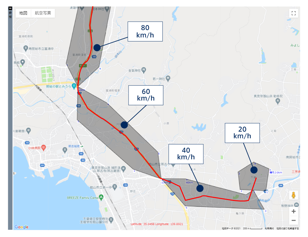
Custom Speeding Judgement Examples
Express Motorway @80 km/h speed limit ‥When Over 90 km/h for more than 5 seconds
National Highway @60 km/h speed limit‥When Over 70km/h for more than 3 seconds
Residential Road @40 km/h speed limit‥When Over 50km/h for more than 3 seconds
On Site @20 km/h speed limit‥When Over 30km/h for more than 3 seconds
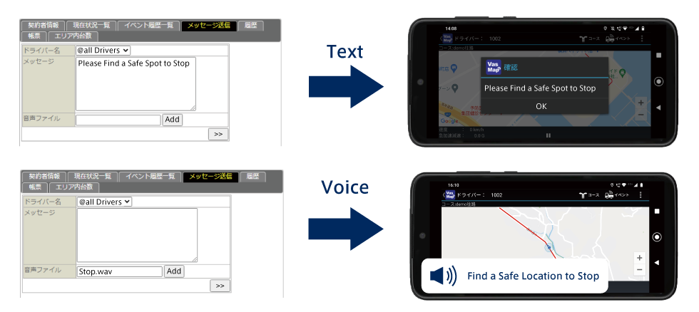
Message Function
VasMap is equipped with a messaging function between the driver and manager.
The manager is able to send a message to the driver’s terminal inside the vehicle.
Through a selection of audio files, audio messages can also be sent directly to the driver.
All these functions are available on an individual basis or as a group basis, allowing the manager to send the same message to specific, multiple or all drivers.
※It is important that drivers must be completely stationary when reading a message from the operator.
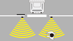
Vehicle Proximity Tracking
VasMap shows other vehicles in close proximity on the driver’s terminal.
The display window can be extended, zoomed or moved around to get a better view of the other vehicle position and direction.
This allows VasMap to be used as a tool for drivers to coordinate together for a safe passage through narrow roads or to plan load/unload spots in worksites.
※A delay of up to 60 seconds may occur
※it is recommended that checks are done while the vehicle is stationary.
Reporting w/ Optional CO2 Emission Calculator
VasMap consolidates the data gathered from the driver’s terminal into daily and monthly reports.
The daily reports will not only show the path taken but also details such as departure, arrival, load/unload time, events and more.
It is also possible to view a report that consolidates all events that occurred across the fleet.
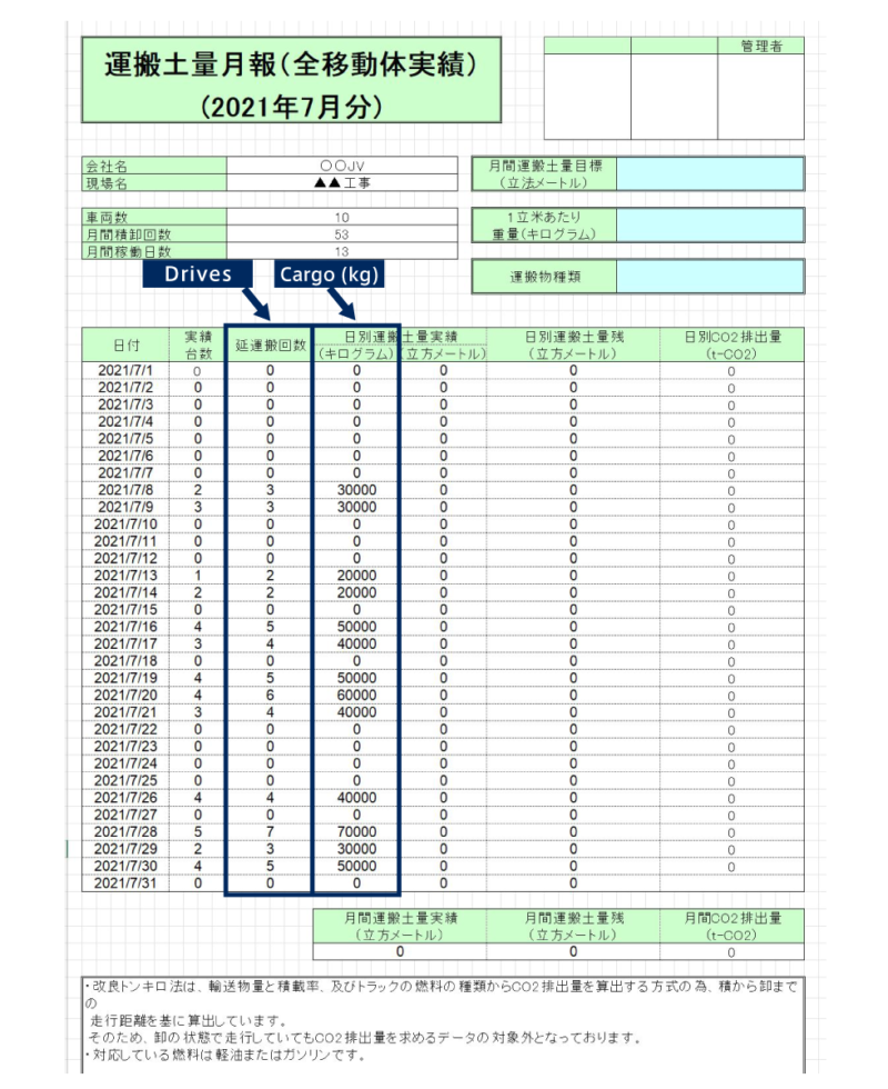
The monthly report consolidates the daily trip, vehicle status, cargo load and other information into a single easy to digest form.
By utilising information such as fuel, cargo and other parameters, automatic CO2 calculation can also be included within the report.
Daily Work Report
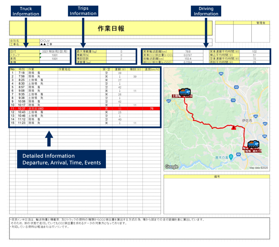
Daily vehicle operation record
Monthly Work Report
Customise Map and Work Area
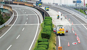
VasMap allows the creation of custom work areas and road lines on existing maps.
This function is used to add roads in areas where the internal road network is not available publicly.
Areas such as airports, extreme rural areas and worksite internal service roads.
It is also possible to trace and confirm route deviation by using the line.
It is also possible to colour in areas on the map using the same tool.
List of Features
Function List on Vehicle
- Sound/Voice Notification
- Real Time Tracking
- Speed Alert
- Event Function
- Messaging Function
- Off Course Alert
Management Function List
- Create/Modify Course
- Create/Edit Custom Charts
- Master Settings
- Vehicle Tracking
- Event Viewer
- Operation History
- Voice/Text Messaging
- Report Exporting
Optional Features
【Optional Features】Real Time Temperature Tracking
The operator can keep track of the cargo temperature in real time by connecting a thermometer with bluetooth capability to the terminal with VasMap installed. Visualise the temperature data in graphs and set an alert when the cargo reaches below or above a certain temperature.
【Optional Features】Vehicle Carrying Capacity Tracking
Keep track of operation carrying capacity by connecting compatible truck scales to the VasMap system directly. The operator can visualise the data using a graph for a quick and easy assessment and tracking of operation status.
※Model Compatibility Applies
※Wireless Communication Device for Scale may be required.
Barcode Login Compatibility
Use barcodes to categorise and track which vehicles are currently being worked on during off/on loading operation.
This system can also be used in the event that a terminal cannot be fixed inside of the vehicle as an alternative method of tracking.
※CSV Format Output
※Barcode Login Requires a Registration on a Master Vehicle Information Database
Specification
| Terminal compatible model (May subject to change) | MediaPad T2 7.0 Pro moto g7 moto g10 |
|---|---|
| Minimum PC Specs | CPU: Pentium III 677MHz Memory: 256MB HDD: 100MB |
| Recommended PC Specs | CPU: Pentium 4 1GHz or higher Memory: 512MB or higher |
| Recommended Browser | Microsoft Edge |
| Recommended Operating System | Microsoft Windows 8, 10 Japanese Version |
| Recommended Spreadsheet | Microsoft Excel 2003 or later |
| Map Scale | 1:1500 |
| Map Updates | Updated as needed in response to changes |